Dickville School - Where was it?
first published 12-01-09, with several edits later
Before 1930 there were many one room school houses in Stanly County. One was the Dickville school serving the area that is now Morrow Mountain State Park.
I've heard some people say the school was on the right side of Morrow Mountain road and just before entering the current park gate. I think this is where the Dick family lived, and at some point in time the school may have been there. That location outside today's park gate does not match information from two maps of the early 1900s. One map is the Miller Map of about 1909. This section of that 1909 map shows the area of interest.
The other map is a 1920 Rural Delivery Map. This section of the map shows the area of interest. The school symbol is included in the legend.
Both maps indicate the school sat inside what is now the park boundary. Both maps show the school sitting on the south side of the old ferry road. In general the road followed the path of the old wagon road. The school appears near the turn toward Ebeneezer Church and by 1917 the town of Badin.
On December 7th, 2007 a video was made of Richard Walter Mills touring the park with Ranger Ron Anundson. Mr. Mills attended the Dickville School. Mr. Mills indicated the school site was on the south side of the old ferry road near the turn toward Badin. He recalled a spring that the children drank from. Mr. Mills also mentions a church on the north side of the ferry road.
Around 1940 a pond was built by the CCC ( Civilian Conservation Corps ) to supply water to the park swimming pool. I believe the location for the pond was chosen in part because of a spring. This would have been the same spring used by the Dickville school.
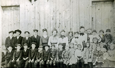
Here is a photo of the Dickville students taken about 1905. This photo appears on page 82 of the book "Our Children's Heritage" by Alberta Lowder Boggan, Copyright 1982.
The next section was added - October 23rd, 2016
Some reports indicate the Dickville School sat across the old Ferry Road from the junction with the road/path from Badin. It is important to remember that the road from Badin has evolved over time. There have been at least two branches of the road coming from Badin.
During the early history of the area the road/path seems to have joined the Ferry road farther east (nearer the river) than it does today. I think this was the case until sometime prior to 1920. The eastern branch would have been the wagon road that Dr. Kron and others took from the Ferry Road on their travels north toward Badin. On the Miller Map of about 1909 there is only one path coming from the direction of Badin. Notice the way in which the road curves.
A second path shows up on the 1920 rural delivery map. I believe this road was created with the increase in automobile traffic. The Rural Delivery Map of 1920 shows two paths branching off the Badin Road and heading south to the ferry road. We can see that the newer western most path is straighter, built for cars. A home site symbol shows up across from the western most junction with the Ferry Road. I believe this was later thought to be the school location. There is a symbol for a school location close to the junction of the old more eastern branch.
I believe that the Dickville School sat on a well known site. It has remained unidentified and unclaimed by any family. That is logical if it was the Dickville School site. That site is near the pond supplying water to the pool. It is on the south side of the ferry road. It is just west of the spot where the fire road joins the ferry road.
I believe I have found the foundation of the church mentioned by Mr. Mills in the video made in 2007. I have found stacked stone foundations on the river or east side of the fire road.
